GIS - Map Control Scale


The Refresh button on the Data tab must be clicked to apply any changes.

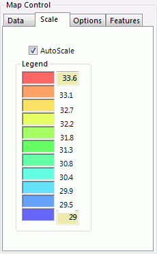
  • AutoScale – Enable AutoScale to set the Legend boundaries based on the highest and lowest data value in the system.  Only generators are shown.

  • Legend – Shows the data values corresponding to the colors on the GIS map.  The highest and lowest values may be modified to adjust the scale.


GIS - Map Controls

The GIS Map Controls box is used to control mapping features and update data graphics.  The Map Controls box has 4 tabs to adjust various settings.

Data

Scale

Options

Features


 GIS

 GIS - Map Control Scale


For further assistance, please contact Aurora Support.

Copyright© 1997-2022 Energy Exemplar LLC. All rights reserved.