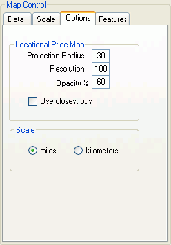
GIS - Map Control Options


The Refresh button on the Data tab must be clicked to apply any changes.

  • Projection Radius - Adjusts the radius of the data circles.

  • Resolution - Adjusts the resolution of the data circles.  

 NOTE: A high resolution will take considerably more time to load.

  • Opacity %  - Adjusts the opacity of the colors of the data graphics.

  • Use closet bus - Applies color to a grid pixel based on the data value of the bus closest to that pixel.

  • Scale - Use to select miles or kilometers for the map display.

GIS - Map Controls

The GIS Map Controls box is used to control mapping features and update data graphics. The Map Controls box has four (4) tabs to adjust various settings.

Data

Scale

Options

Features


 GIS

 GIS Map Control Options


For further assistance, please contact Aurora Support.

Copyright© 1997-2024 Energy Exemplar LLC. All rights reserved.